Simplifying Plot deliniation with AI and Aerial Imagary
- February 28, 2021
- Blog, Products
- Posted by Felix.Weber
- Comments Off on Simplifying Plot deliniation with AI and Aerial Imagary
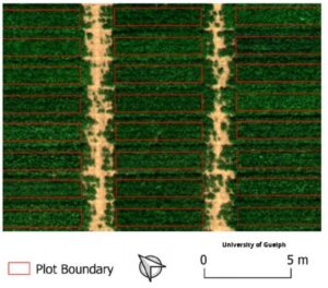 The University of Guelph has developed a method for precisely aligning aerial imagery over time with plot boundaries, that are fixed and do not vary from image to image. Plot extraction from aerial imagery: A precision agriculture approach (wiley.com)
